


Digital cemetery mapping using the ZuluGIS geographic information system
Digital cemetery mapping represents human graves in virtual space where anyone can find the required gravesite using the surname, name, and patronymic of the deceased, and view its condition based on the posted photographs. However, this is only the visible, social side of the service. A geographic information system (GIS) with a burial records database primarily allows you to bring each grave under control, eliminating the possibility of profiteering from uncontrolled burials. It is one of the priorities pursued by the reform of the death care market, which was initiated by the President. The municipal authorities have been making an inventory of graves since the 2000s but began to use GIS only in 2013. Our company Sole Proprietor «Ilyin G.V.» has been using the ZuluGIS geographic information system for this purpose for several years, with certain adjustments to the data input stage when inventorying. More on this below.
When using and exchanging data, the standard Zulu tools suffice. Not only specialists of the municipal services but also ordinary citizens recognize and appreciate the system's usability. When making an inventory, the following information is determined and entered into GIS: the exact boundaries of burial plots, their detailed maps containing roads and main objects, a database with a general view of each burial site georeferenced to its location, the placement of gravestone structures and separate photographs of each grave with the data of the buried person and each plot. ZuluGIS makes it possible to assess the state of land resources in cemeteries, identify empty plots, abandoned and unattended graves, solve the problem of illegal demolition of burial sites, and unauthorized occupation of areas for burial. The use of GIS also makes it possible to prevent double burials, while the accuracy of plot boundaries (the margin of error is +15 cm) once and for all eliminates the problem of neighbor disputes when replacing fences or installing new gravestones or monuments.
Using this software, you can keep daily records of the activities of all funeral service organizations, accurately determine the market share occupied by each one of them, calculate profits to estimate taxes, and monitor the actions of employees and contractors involved.
Moreover, ZuluGIS allows you to personalize all updates to the burial database and have a complete picture of by whom, when and for what purpose they were made, to rule out any corruption.
Any given section of the GIS service can be accessed only by those specialists whose functional responsibilities include filling it in; alternatively, the access is limited by certain permissions.
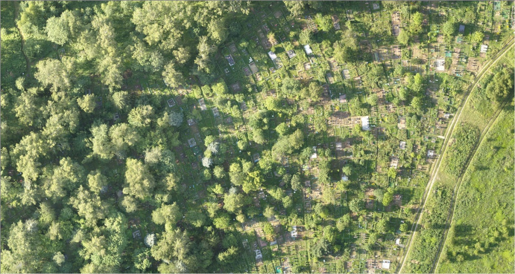
The complete inventory involves four steps. We recommend that you start with digitizing the burial records and archives, which in many cases help to track down information about those buried in graves without any identification marks. Then comes the fieldwork, where a cartographic survey of cemeteries is carried out using unmanned aerial vehicles and land-surveying equipment.

We use the most affordable GNSS module - the Emlid Reach receiver. It has one frequency but readily provides the stated accuracy. To ensure that the exact coordinates are entered from the receiver directly into ZuluGIS Mobile bypassing the intermediate stage in the receiver software and export-import operations, you need to replace the standard set of GPS smartphone capabilities with "dummy coordinates" obtained from the GNSS receiver.

Only then does ZuluGIS Mobile begin to "see with the eyes" of the survey pole with the receiver. You can stay in one place within the WiFi range between the receiver and the smartphone; your assistant moves from one corner of the fence to another while you draw the positioning results.

In this way, a digital map of burial plots (fences) appears. The next step is a complete survey of all graves and empty plots without exception, processing and entering information into the ZuluGIS database.

Making an inventory of each cemetery can take from one to several months, depending on its size; once begun, the process should not stop. People pass away every day, and you should update the databases accordingly. Cemetery inspectors should enter photographs and coordinates of all new burials into the program, which automatically processes them. The interval for making an inventory of graves varies from 1 to 3 years.


Making an inventory of each cemetery can take from one to several months, depending on its size; once begun, the process should not stop. People pass away every day, and you should update the databases accordingly. Cemetery inspectors should enter photographs and coordinates of all new burials into the program, which automatically processes them. The interval for making an inventory of graves varies from 1 to 3 years.

When combining several burial databases for each cemetery, the program is used as a unified register of all burial sites of an urban district – a municipal geographic information system, which will allow citizens to monitor the final resting places of their loved ones and will enable the authorities to bring the entire death care industry out of the shadows and get full control over it.
The municipal authorities can use ZuluGIS to create a municipal geographic information system for digital records, a burial sites database, and a digital inventory as part of the Smart City urban digitalization project, the Housing and Urban Environment national project, and the Digital Economy national program.
Georgy Ilyin, sole proprietor Phone: 8(985)7700300